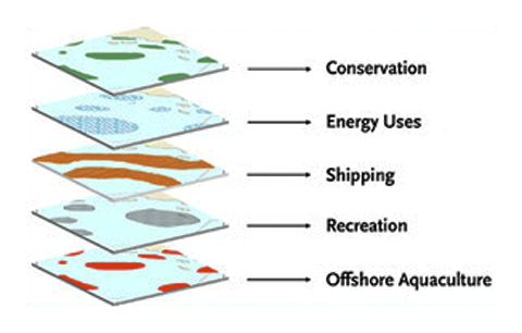
Coastal & Marine Spatial Planning
NANOOS and the larger IOOS community it represents are poised to make critical contributions to the new CMSP frameworks, policies and plans being developed in Washington and Oregon as well as future regional planning efforts, including those established under the national CMSP framework. NANOOS’s priority areas of Marine Ecosystems, Fisheries and Biodiversity, Maritime Operations, Coastal Hazards and Climate are directly relevant to CMSP concerns and will benefit from an overarching CMSP perspective. NANOOS is engaged with regional CMSP efforts by supporting needs assessments, participating in regional coordination projects, and facilitating discussions to identify objectives and tasks that take advantage of NANOOS's specific strengths to complement those of other CMSP partners. NANOOS has become an important regional partner through its distinct role coordinating marine monitoring, providing data access through innovative products and services, and maintaining outreach with stakeholders and resource managers.
CMSP activities that NANOOS is participating in include:
- Maintain the monitoring asset inventory to provide information about the spatial footprint of coastal and marine research in the Pacific Northwest.
- Collaborate with other IOOS West Coast Regional Associations (CeNCOOS and SCCOOS), the West Coast Coastal Atlas community, and Integrated Ecosystem Assessment regional leads (including the South Slough NERR), to integrate shared goals and efforts that support efforts aimed at the regional implementation of the National Ocean Council’s and the West Coast Governors’ Agreement on Ocean Health (WCGA) CMSP goals.
- Develop maps and spatial assessments synthesizing temporally dynamic marine water habitats and key oceanographic processes, and make such data readily accessible to decision makers, planners, stakeholders, and support staff at agencies.
- Facilitate regional CMSP data discovery and interoperability efforts that are informed by national priorities and IOOS resources while serving regional needs. This effort includes active support for the emerging local and regional data networks: the Oregon Coastal and Marine Data Network (Workshop report) and the West Coast Regional Data Network.
- Assist in the Washington and Oregon CMSP priority area of marine renewable energy by supporting the development guidelines for baseline oceanographic observations and create and distribute useful data-analysis products to decision makers and stakeholders.
Additional Resources
White House, National Ocean Council
NOAA Coastal and Marine Spatial Planning Portal
Consortium for Ocean Leadership: Science Requirements for Marine Spatial Planning
United Nations Educational, Scientific, and Cultural Organization (UNESCO) Marine Spatial Planning Initiative
Related NANOOS Products
NANOOS Asset List
Inventory of NANOOS assets.
NANOOS Visualization System (NVS)
The NANOOS Visualization System (NVS) provides easy access to forecast and observation data across a wide range of assets such as buoys, shore and land stations, high-frequency radar, and satellites.
Tsunami Evacuation Zones
Interactive tsunami inundation maps developed for Oregon and Washington coastlines, accessible through the NVS Tsunami Hazards Portal.
Oregon Coastal Atlas
Information for different coastal systems, access to interactive mapping, online geospatial analysis tools, and direct download access to various planning and natural resource data sets relating to coastal zone management.
Washington Coastal Atlas
Relevant information for use in coastal and shoreline resource planning and management. Information provided includes: locations of public beaches; location of beach closures; and an interactive coastal map.
NANOOS members involved in this effort include:
Oregon Dept. of Land Conservation and Development (ODLCD)
DLCD's Oregon Ocean Information Website
Oregon Dept. of Geology and Mineral Industry (DOGAMI)
| National Observing System Partners Alliance for Coastal Technologies (ACT) Southeastern Universities Research Association (SURA) Integrated Ocean Observing System IOOS | |||||||