Coastal & Marine Spatial Planning
In 2010, President Obama released the National Policy for the Stewardship of Our Oceans, Coasts, and Great Lakes that adopts an ecosystem-based approach to management and an overarching framework of regional-scale CMSP. Previous to this framework, organizations in the Pacific Northwest had already embarked on CMSP efforts. In response to two national reports, the governors in CA, OR, and WA created the West Coast Governors' Agreement (WCGA) in 2006 to cohesively manage and protect the West Coast’s ocean and coastal resources. Specific efforts in the PNW include updating the Territorial Sea Plan and designating marine reserves in Oregon, and passing of a new law in Washington to create a state MSP plan. More recently, the WCGA and its regional partners have worked collaboratively towards the creation of a regional CMSP framework via a grant proposal submission in early 2011 to NOAA that sought funding for these efforts on the West Coast, and in planning for the West Coast Regional Data Network Workshop to be held December 13–14, 2011, in Oakland, California.
Additional Resources
White House, National Ocean Council
NOAA Coastal and Marine Spatial Planning Portal
Consortium for Ocean Leadership: Science Requirements for Marine Spatial Planning
United Nations Educational, Scientific, and Cultural Organization (UNESCO) Marine Spatial Planning Initiative
Related NANOOS Products
NANOOS Asset List
Inventory of NANOOS assets.
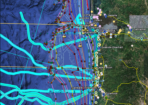
NANOOS Visualization System (NVS)
The NANOOS Visualization System (NVS) provides easy access to forecast and observation data across a wide range of assets such as buoys, shore and land stations, high-frequency radar, and satellites.
Tsunami Evacuation Zones
Interactive tsunami inundation maps developed for Oregon and Washington coastlines, accessible through the NVS Tsunami Hazards Portal.
Oregon Coastal Atlas
Information for different coastal systems, access to interactive mapping, online geospatial analysis tools, and direct download access to various planning and natural resource data sets relating to coastal zone management.
Washington Coastal Atlas
Relevant information for use in coastal and shoreline resource planning and management. Information provided includes: locations of public beaches; location of beach closures; and an interactive coastal map.
NANOOS members involved in this effort include:
Oregon Dept. of Land Conservation and Development (ODLCD)
DLCD's Oregon Ocean Information Website
Oregon Dept. of Geology and Mineral Industry (DOGAMI)
| National Observing System Partners Alliance for Coastal Technologies (ACT) Southeastern Universities Research Association (SURA) Integrated Ocean Observing System IOOS | |||||||